Western Desert Tour
![]()
![]()
![]()
![]()
![]()
![]()
www.victoria-reto.com
We left Cairo quite late towards Baharriya, but as we drove the road a week before we did not mind
South of Bahariyya, the classical Oasis route
This is the famous Black Desert hill which tourists from Baharriya come to visit. We will see many more similar hills on our Western Desert Tour
Stones from Crystal Mountain are nice and transparent. It is near the tarmac road, so it is often visited
Crystal "Mountain", next to Baharriya - Dakla road
White Desert, Egypt
Ned posing for a picture. He was one of the two other tourists on our Western Desert Tour
The White Desert attracts many tourists
White Desert, Egypt
White Desert, Egypt
White Desert, Egypt
White Desert, Egypt
White Desert, Egypt
White Desert, Egypt
Leaving the White Desert in Southern direction towards Dakla oasis
The White Desert has some soft patches which produce a lot of dust when driving through
Leaving the White Desert in Southern direction towards Dakla oasis
The brownish colored sand only covers the white talg below
On the way from the White Desert in southern direction towards Dakla oasis
On the way (well, with a break...) from the White Desert in southern direction towards Dakla oasis.
pushing out went surprisingly easy
On the way from the White Desert in southern direction towards Dakla oasis
On the way from the White Desert in southern direction towards Dakla oasis
On the way from the White Desert in southern direction towards Dakla oasis
On the way from the White Desert in southern direction towards Dakla oasis
On the way from the White Desert in southern direction towards Dakla oasis
On the way from the White Desert in southern direction towards Dakla oasis
On the way from the White Desert in southern direction towards Dakla oasis
On the way from the White Desert in southern direction towards Dakla oasis
On the way from the White Desert in southern direction towards Dakla oasis
On the way from the White Desert in southern direction towards Dakla oasis
A few km North of Dakla Oasis
A few km North of Dakla Oasis
Dakla Oasis
Desert Lodge, Dakla
View South from Desert Lodge, Dakla
View North from Desert Lodge, Dakla
Desert Lodge, Dakla
Hot Spring at Desert Lodge, Dakla. Very pleasant after a day out in the desert
Islamic City, Dakla Oasis. Today, there remain only a few inhabitants in the old town which is picturesque. An inhabitant acts as tourist guide.
Old Mill in Islamic City, Dakla Oasis
Islamic City, Dakla Oasis
Dakla Oasis, green fields with sand dunes in background
On our way from Dakla in South-Eastern direction
On our way from Dakla in South-Eastern direction
On our way from Dakla in South-Eastern direction
On our way from Dakla in South-Eastern direction
We joined an organised trip to the Western Desert - we were a total of 3 vehicles
Abu Ballas, the water reservoir that enabled medieval attacks on Dakla Oasis
Abu Ballas
View from Abu Ballas
After we had lost the track of our guides vehicle, we took a picture in case it would happen again
It is surprising how quickly you loose sight of another vehicle on a seemingly flat sand sheet
Mud loins, formations that were created as the area was still covered with water
Mud lions, Western Desert, Egypt
In 1977 Saviem/Renault crossed a large part of the Sahara and left sign-posts - which can be seen on Michelin maps
On sand it is best to not drive in a previous track
You develop a different sense for distance
The two other tourists on the tour, Steve and Ned
The landscape is varied and changes frequently
Gilf Kebir (with Victoria)
This truck did not survive the British Long Range Desert Tour of 1942
Our group (without the 3 people in the support truck) from left to right: Guide, Victoria, Military Officer, Ned, Reto, Steve
The failing truck led to a fuel stop for the others. We were impressed how the desert was crossed during WW II
Western Desert, Egypt
At the end of a wadi a barrier dune enabled a lake to form in prehistoric times. Humans lived on the shores
and today left-overs such as arrow-heads can be found
Western Desert, Egypt
Airport of 8 Bells, used in WW II
Detail of the arrow of 8 Bells airport
Cruising over the great sand sheets towards Uweinat was easy and fast in some areas
On the way to Uweinat (guides vehicle)
Crossing the border Egypt/Sudan near Uweinat (no border post)
Sudanese side of Uweinat. Despite some trees, there is no surface water or a well
Uweinat, Sudan
Uweinat has many prehistoric rock art remains
Uweinat has many prehistoric rock art remains
Uweinat has many prehistoric rock art remains
Uweinat, Sudan
Uweinat has many prehistoric rock art remains
Caravans used to stop in Uweinat, but not all camels survived. There are many skeletons
Uweinat, Sudan
Uweinat, Sudan
Another border sign Sudan/Egypt
Heading North from Sudan through Egypt to Lybia
Heading North from Sudan through Egypt to Lybia
Heading North from Sudan through Egypt to Lybia
Remains of an Egyptian Military Truck. Desert driving is tough on vehicles
Top of the Aqaba Pass (Gilf Kebir, Egypt), a long and sandy ascent. If you don't make it in one go, you should drive down and try again...
View on the Aqaba Pass (Gilf Kebir, Egypt)
Aqaba Pass, Gilf Kebir, Egypt
near Wadi Sora, Egypt
near Wadi Sora, Egypt
near Wadi Sora, Egypt
Our campspot near the Cave of the Swimmers
near the Cave of the Swimmers
2 out of the 9 swimmers
Cave of the Swimmers, Egypt
View from the Cave of the Swimmers
Victoria showing two little swimmers
Cave of the Swimmers
Cave of the Swimmers
Western Desert, Egypt (very near to Lybia)
Fugini Cave, near Cave of the Swimmers
Fugini Cave, near Cave of the Swimmers. It is also known as Cave of the Hands
View from Fugini Cave
Fugini Cave, near Cave of the Swimmers
View from Fugini Cave, near Cave of the Swimmers
Fugini Cave, near Cave of the Swimmers
Fugini Cave, near Cave of the Swimmers
Heading North-West from Cave of the Swimmers
Heading North-West from Cave of the Swimmers
Reto discovered the Matterhorn mountain in Egypt
Heading North-West from Cave of the Swimmers
Tea Stop in Lybia
Border sign Egypt/Lybia (no border post)
Lybia/Egypt border area
Lybia/Egypt border area
Lybia/Egypt border area
Lybia/Egypt border area has fine sand, which is more like dust
Lybia/Egypt border area
Antar, the driver of the Liaz truck. He is very experienced
Lybia/Egypt border area
Lybia/Egypt border area
Lybia/Egypt border area
Reto was allowed to drive in the truck for a while. It was bumpier and slower than in a Toyota
Lybia/Egypt border area
Victoria using our solar shower in Wadi Abdelmalik
Reto drying himself and keeping warm after showering
It got cold that night, as our guide proves (the skiing gloves are from Austria)
Loading Diesel in the desert
Wadi Abdelmalik, Egypt
Wadi Abdelmalik, Egypt
Lonely tree in Wadi Abdelmalik, Egypt
Wadi Abdelmalik, Egypt
Egypt/Lybia border area
Egypt/Lybia border area
The southern tip of the "Great Sand Sea". When trying to make a picture, we suddenly got stuck...
The quickest solution for getting out of a soft patch of sand is by being pulled
Southern end of the "Great Sand Sea"
Southern end of the "Great Sand Sea"
Southern end of the "Great Sand Sea"
Self-Exposure during our sundowner snack, where we spent the night, on a dune above the silica glass area
Our nightspot on a dune above the silica glass area. Please note Victorias exclusive toilet
Our nightspot on a dune above the silica glass area.
Victoria looking for Silica Glass
Silica Glass
Truck crossing a dune
Truck crossing a dune
Typical tea stop
Cruising through the Great Sand Sea
Cruising through the Great Sand Sea
Great Sand Sea, Egypt
Used fuel barrels are used as indicators and can be spotted from far away
The nights were less windy in the Great Sand Sea, so we were able to use the fire-wood brought from Cairo
Campspot in the Great Sand Sea, Egypt
In the morning a strong wind picked-up - by 11am it was a sand storm. The truck was very unfortunate to then have a flat tire
Changing tire in the Great Sand Sea during a sand storm
Changing tire in the Great Sand Sea during a sand storm
Visibility was obviously poor - we tried to drive as close as possible...
... which prevented us from keeping the sometimes required speed for crossing soft patches of sand. So we got stuck...
But the truck was a lot worse off - he got stuck 10 times that day
The truck managed to move far in soft sand, leaving deep tracks behind. But sometimes, it was not far enough...
Our support truck in the Great Sand Sea
Sand blowing off a dune
In the evening the wind settled down and we spent a pleasant night
The next day there was only little wind
The truck driving down a dune, the guides vehicle can be seen in the distance
Petrified wood
Petrified wood
A little pull can make all the difference
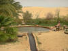
Bir Wahid, near Siwa Oasis
Great Sand Sea, near Siwa Oasis, Egypt
After 2'000km offroad we were back on asphalt
After 2'000km offroad we were back on asphalt (the first few km from the last gas station were not offroad)
Road in Siwa Oasis, known also for its over 300'000 palm trees
Qara Oasis, Qattara Depression, Western Desert, Egypt
Qara Oasis, Qattara Depression, Western Desert, Egypt
Since centuries, there are always only about 400 people living there
Qara Oasis, Qattara Depression, Western Desert, Egypt
Since centuries, there are always only about 400 people living there
Heading North towards the Mediterranean Sea
The desert becomes liveable the more North you get
Marsa Matruh, on the Mediterranean Coast, Egypt
We crossed Egypt from South to North on our Tour of the Western Desert
There were 30cm wide patches of very hard sand followed by 2 meters of very soft sand. After a few hard and high "flights" from on to the next, Reto drove slower - then we were suddenly stuck...
It is a scenic one day drive (if you don't get stuck too often).
There was one sandy pass that required us to lower tyre pressure in order to make it up
There was one sandy pass that required us to lower tyre pressure in order to make it up
After another ascent we reached the most scenic pass we have been to in a desert environment
It looks like a glacier, but it is sand. Skiing might be possible...
The truck transported one barrel (240 litres) of diesel for us from Dakla to Uweinat, which was a comfy solution as we did not need to put 12 jerry cans in our car. That would have reduced our living-space noticeably. Our Land-Cruiser used 20 litres of diesel per 100 km on this tour, as there was a lot of sand-driving which required full power in low gears
After 10 days with no water- and fuel available on the trip, we were happy to arrive in Bir Wahid, a pool in the Great Sand Sea about 10km South of the Siwa Oasis


 from the White Desert in southern direction towards Dakla oasis.")


")

 from left to right: Guide, Victoria, Military Officer, Ned, Reto, Steve")


")
")


, a long and sandy ascent. If you don't make it in one go, you should drive down and try again...")
")


")


")


")


")


 .
.

|

We left Cairo quite late towards Baharriya, but as we drove the road a week before we did not mind